|
|
|

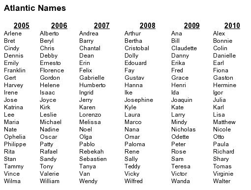
Since 1953, Atlantic tropical storms have been named from lists originated by the National Hurricane Center and now maintained and updated by an international committee of the World Meteorological Organization . The lists featured only women's names until 1979, when men's and women's names were alternated. Six lists are used in rotation. Thus, the 2005 list will be used again in 2011.
The only time that there is a change in the list is if a storm is so deadly or costly that the future use of its name on a different storm would be inappropriate for reasons of sensitivity. If that occurs, then at an annual meeting by the WMO committee (called primarily to discuss many other issues) the offending name is stricken from the list and another name is selected to replace it.
Several names have been changed since the lists were last used. Four names from the 1995 list have been retired. On the 2001 list, Lorenzo has replaced Luis, Michelle has replaced Marilyn, Olga has replaced Opal, and Rebekah has replaced Roxanne. Three names from the 1996 list have been retired. On the 2002 list, Cristobal has replaced Cesar, Fay has replaced Fran, and Hanna has replaced Hortense. Two names from the 1998 list have been retired. On the 2004 list, Gaston replaced Georges and Matthew replaced Mitch.source
|
Storm tracking & prediction that didn't quite work as well as planned...or did it?
|
Unraveling a mystery: Shuyi Chen, associate professor at the Rosenstiel School, says project RAINEX could lead to a better understanding of rapid changes in hurricane intensity, a phenomenon that has baffled researchers for years.
|
Storm Trackers
. Excerpted from Veritas, September 2005 -
Hurricane Keith gave residents of much of Central America a frightening and startling surprise five years ago. A minimal Category 1 storm before it made landfall, Keith unexpectedly intensified within 18 hours into a strong Category 4 hurricane, pounding the coastal islands of Belize with
140-mph winds and heavy rain for more than a day.
During last year's unusually busy Atlantic hurricane season, Hurricane Charley gave residents of Florida's Gulf Coast a similar surprise, exploding from a Category 3 to a Category 4 storm only 24 hours before striking Captiva with 150-mph winds.
Changes in storm intensity such as these examples have dumbfounded forecasters for years. But now a new study by a University of Miami researcher holds the promise of more accurately predicting when, how, and why a storm can change in strength in only a matter of hours. The Hurricane Rainband and Intensity Change Experiment, or RAINEX, will study how the outer rain bands, inner eye, and eye wall of a hurricane interact to influence a storm's intensity. While researchers have studied the eye and outer rain bands of hurricanes extensively, "few, if any, experiments have ever examined these two components together and how their interaction might affect a storm's strength," says Shuyi Chen, an associate professor of meteorology and physical oceanography at the Rosenstiel School of Marine and Atmospheric Science and the project's principal investigator.
|
|
"The outer bands of a hurricane often have strong winds and lots of rain, and that can actually have something to do with the overall intensity change of a hurricane," Chen says.
"No other hurricane research project has ever used three aircraft with Doppler radar flying at the same time into a hurricane."
Chen and her Rosenstiel School colleagues will study this interaction using data recorded from hurricane reconnaissance flights. During this year's Atlantic hurricane season, two P3 aircraft from the National Oceanic and Atmospheric Administration (NOAA), along with a U.S. Navy aircraft, will fly simultaneously into hurricanes well before the storms threaten landfall.
Flying in the hurricane's outer bands and punching into the eye wall on most flights, the aircraft will use sophisticated Doppler radar and weather reconnaissance devices called dropsondes to record wind speed, temperature, humidity, atmospheric pressure, and other critical data.The flights will be made from mid-August to early October.
The study is the first of its kind. "No other hurricane research project has ever used three aircraft with Doppler radar flying at the same time into a hurricane," says Chen, who went through a week of physical and water-survival training at the Jacksonville Naval Air Base so that she can accompany pilots on some of the flights.
The project is funded by a $3 million grant from the National Science Foundation, and two other research institutes are collaborating with UM on the project. The University of Washington and the National Center for Atmospheric Research in Boulder, Colorado, will provide expertise in airborne Doppler radar analysis. UM will provide expertise in computer hurricane modeling and will record results from the hurricane reconnaissance flights.
The scientists are confident that RAINEX will help augment what they already know about hurricanes, as well as yield new information.
Much of what scientists currently know about the interaction between the outer rain bands and the eye wall of a hurricane comes from numerical models, which can provide very detailed information but may not be completely accurate. What researchers are still missing is solid data to validate these models. "We need to know whether or not what our models are telling us is accurate, and hopefully the data we collect from RAINEX will give us the information we need to validate our model results," Chen says.
Once the data are collected, they will be analyzed by all of the researchers involved in the project and shared with hurricane operational centers and national environmental prediction centers throughout the country and around the world.. - miami.edu
|
|
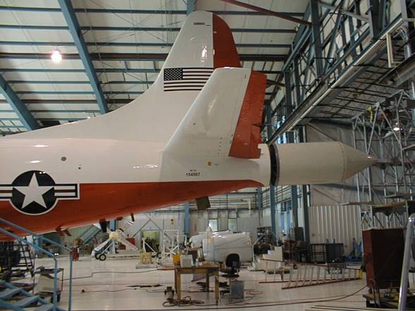
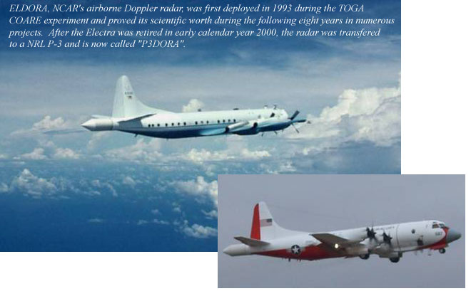
IHOP Preparations - Transforming a military aircraft into a versatile research platform
After the decision by NSF and NCAR to retire the Electra aircraft, the Foundation identified a Naval Research Lab (NRL) P-3 as the only viable, cost-effective platform to carry the airborne Doppler radar ELDORA, thereby preserving this important research tool for use by the NSF community. The P-3 actually has capabilities that exceed those of the Electra, namely, the ability to fly into hurricanes and longer endurance. Explicit planning for the transition of ELDORA onto the P-3 was formalized in spring 2001 by appointment of the ATD P-3 Transition Team. The team, lead by RAF engineer Mike Spowart, included several engineers, technicians, scientists and administrators from within ATD; the team was charged with utfitting the P-3 in less than 12 months for two imminent field programs, IHOP 2002 and Crystal FACE.
The outfitting of the P-3 included:
Physical transfer and installation of ELDORA from the Electra to the P-3;
Installation of the French Leandre II Water Vapor Differential Absorption Lidar (DIAL) including the design and construction of a window fairing;
Development of the "Pip Squeak" eye-safe radar;
Outfitting of the aircraft interior with instrumentation racks, data and communications system;
Installation of supporting meteorological sensors including the Tunable Diode Laser (TDL).
The ELDORA radome installed on the NRL P-3 at the Research Aviation Facility hangar. The radome antenna is being mated to the trail of the P-3. The rest of the ELDORA equipment was installed in racks inside the cabin.
The transfer of ELDORA and the installation of other IHOP instrumentation was complicated by a Navy requirement that all equipment be 20 G compliant. As a consequence, the electronics for ELDORA, the Aircraft Data System (ADS), the Weater Avoidance Radar (WARDS) and the French DIAL had to be repackaged and fit into specially- designed racks built by a Navy contractor and ATD's Design and Fabrication Services. The repackaging also required major rewiring within the aircraft. - atd.ucar.edu/
|
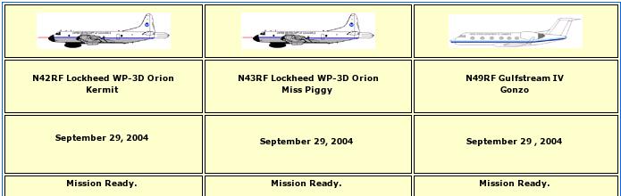
| Lockheed WP-3D Orion
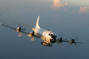
Two of the world's premier research aircraft, the renowned NOAA WP-3D Orions, participate in a wide variety of national and international meteorological, oceanographic and environmental research programs in addition to their widely known use in hurricane research and reconnaissance. These versatile turboprop aircraft are equipped with an unprecedented variety of scientific instrumentation, radars and recording systems for both in-situ and remote sensing measurements of the atmosphere, the earth and its environment. Obtained as new aircraft from the Lockheed production line in the mid-70's, these robust and well maintained aircraft have led NOAA's continuing effort to monitor and study hurricanes and other severe storms, the quality of the atmosphere, the state of the ocean and its fish population, and climate trends.
|
|
|
|
With their world-wide operating capability, they have participated in numerous research experiments from the Indian Ocean, Australia and the Solomon Islands to Ireland, the North Sea and the Alps. On a national scope they have operated from the Arctic Ocean and Alaska through most regions of the U.S. and into the Caribbean. Hurricane and tropical storm research have taken place in the Atlantic, Caribbean, Gulf of Mexico and the Eastern Pacific. Estimated useful lifetime for these two research platforms is another 10 to 15 years. - noaa.gov
|
|

The NOAA Gulfstream IV-SP (G-IV) flew into the eye of Hurricane Fabian, a Category 4 storm, on September 1st, 2003. The aircraft launched from St. Croix at 1251 EDT and landed back in St. Croix at 1607 EDT. On September 1st, Fabian was located about 450 miles northeast of the U.S. Virgin Islands. From Air Force Reconnaissance aircraft reports, the storm slightly intensified from 946 mb at 1 pm EDT to 942 mb at about 3 pm on September 1st. The five-person crew, all from AOC, were testing the aircraft response to meteorological conditions near the core of a strong hurricane.
Flying at 41,000 feet, and approaching Fabian's eye from the southwest, the crew noted a well-formed eye on radar, stronger on the north side than on the south and west. Arriving at a point about 50 miles south of the eye, after thorough analysis of the storm using radar, they decided to head for the center. Once through the south eyewall, the pilots turned to the southwest over the Fabian's circulation center, and the crew released four dropwindsondes (more information about dropwindsondes can be found at the University Corporation for Atmospheric Research web site) while inside the eye. These dropsondes used GPS navigation and meteorological sensors to measure temperature, humidity, pressure, wind direction and wind speed as they descended in Fabian's eye. One dropwindsonde measured a low-altitude wind gust of 71.2 m/s, or about 138 knots, and all of the sondes inside the eye measured surface pressures below 950 millibars. The G-IV exited the eye to the southwest.
- noaa.gov
|
3rd aircraft added 2005
Third Aircraft Added To Hurricane Fleet Will Measure Why Systems Strengthen
(South Florida Sun-Sentinel)By Ken Kaye Staff Writer Posted: August 9, 2005
Three large aircraft plan to attack the next hurricane that threatens
the U.S. coast, hunting for rain bands.
The objective: Study the relationship between the bands and the storm
core to help scientists understand why systems rapidly intensify, a
forecasting area that remains a struggle.
"In order to improve the forecasts, we have to understand what is
going on inside hurricanes," said Shuyi Chen, an associate professor
of meteorology at the University of Miami.
Under a $3 million federal research project unveiled Monday, a Navy
P-3 Orion, a rugged four-engine turboprop, will join two National
Oceanic and Atmospheric Administration P-3s, which already are
assigned to investigate hurricanes before landfall. The three planes, flying different patterns and at different
altitudes, will employ Doppler radar, GPS and remote sensors to
determine wind speeds, pressure, rainfall and other storm parameters.
With that information, researchers hope to develop more sophisticated
computer models to forecast intensity.
"There has never been an observational experiment, where we look at
the inner core and rain bands simultaneously," said Robert Rogers,
director of the NOAA's hurricane field program.
In all, five airplanes could be buzzing the same storm.
In addition to the three P-3s, a NOAA Gulfstream-IV high altitude
surveillance jet will fly around the perimeter of storms to collect
atmospheric information. And an Air Force Reserve W-130 hurricane
hunter will feed critical forecasting data to the National Hurricane
Center in Miami-Dade County.
"It obviously requires coordination. We need to know where every
aircraft is going before they head out there," Rogers said.
The P-3 triad will be deployed for the rest of this season, and they
could be busy. Up to nine more hurricanes are forecast to develop,
and an unprecedented nine systems already have emerged.
The National Science Foundation is funding the collaborative project,
officially called the Hurricane Rainband and Intensity Change
Experiment, or RAINEX, and which includes several agencies.
After analyzing data from the research flights, the University of
Miami's Rosenstiel School of Marine & Atmospheric Science plans to
construct a state-of-the-art computer-forecasting model.
The University of Washington and the National Center for Atmospheric
Research will analyze the Doppler radar data. The Naval Research
Laboratory is providing the extra P-3, which has a special Doppler
radar device built into its tail. While track forecasts have made great strides in the past 15 years,
intensity forecasts have improved little, as evidenced by Hurricane
Charley, which unexpectedly morphed into a Category 4 system before
slamming Punta Gorda almost a year ago. Although rain bands had been studied previously, scientists have
found they can provide a destructive punch, even if the bands are
hundreds of miles from the core. For example, even though the center of Hurricane Dennis was in the
Gulf of Mexico, one of its outer bands unleashed winds up to 80 mph
and heavy rains, causing minor but widespread damages and flooding in
South Florida on July 9.
"The outer bands of a hurricane often have strong winds and lots of
rain, and that can actually affect the overall intensity of a
hurricane," Chen said.
Ken Kaye
|
hang on! they already used three aircraft back in 2003
|
December 14, 2001 - Science Overview of the Bow Echo and MCV Experiment (BAMEX)
Planned Dates: 20 May, 2003 to 6 July, 2003
BAMEX is a study using highly mobile platforms to examine the life cycles of mesoscale convective systems. It represents a combination of two related programs to investigate (a) bow echoes, principally those which produce damaging surface winds and last at least 4 hours and (b) larger convective systems which produce long lived mesoscale convective vortices (MCVs). MCVs can focus new convection and play a key role in multi-day convective events affecting a swath sometimes more than 1000 km in length with heavy to perhaps flooding rains. The main objectives regarding bow echoes are to understand and improve prediction of the mesoscale and cell-scale processes that produce severe winds. For MCV producing systems the objectives are to understand MCV formation within MCSs, the role of MCVs in initiating and modulating convection, the feedback of convection onto MCV intensity, and to improve the overall predictability of the vortex-convection coupled system.
|
|
|
We propose to use three aircraft, two equipped with dual Doppler radar capability, the third equipped with dropsondes, to map the mesoscale evolution of long-lived MCSs including the development of mesoscale vortices and rear-inflow jets. Dropsondes will be used to document environmental structure, thermodynamic structure of the stratiform region (where rear-inflow jets and MCVs reside) and to capture the structure of mature MCVs in the absence of convection. In addition, a mobile array of ground-based instruments will be used to augment airborne radar coverage, document the thermodynamic structure of the PBL, including any existing convergence boundaries, probe the surface cold pool, and measure surface horizontal pressure and wind variations behind the leading convective line. The combination of aircraft and ground-based measurements is important for understanding the coupling between boundary-layer and free-tropospheric circulations within MCSs, and, in particular, how the rear-inflow penetrates to the surface in nocturnal severe wind cases.
SCIENCE OVERVIEW OF THE BOW ECHO AND MCV EXPERIMENT (BAMEX)
|
|
Figure 2.8. GOES-8 visible satellite imagery depicting a long-lived MCV at (a) 1615 UTC 20 August, (b) 2115 UTC 20 August, (c) 2315 UTC 20 August, and (d) 1815 UTC 21 August 1998. Adapted from Trier et al. (2000a).
|
|
Bow Echo and Meso-Scale Convective Vortices Experiment happened on May 19th 2003
Fresh out of a major maintenance overhaul and fully instrumented by AOC engineers and technicians for severe storm research, a NOAA P-3 called Kermit deployed from its home at MacDill Air Force Base to Mid America airport in western Illinois, just east of St. Louis, Missouri, on May 19th to participate in the Bow Echo and Meso-Scale Convective Vortices Experiment, known by the acronym BAMEX. Operating with another Doppler radar equipped aircraft, provided by the Naval Research Lab (NRL), and a high-altitude dropsonde Lear jet provided by Weather Modification Inc. of Fargo, North Dakota, NOAA 42, Kermit's call sign, is slated to provide approximately 150 hours of flight time to this severe weather project.
In scientific jargon, the objectives of BAMEX are to:
1. Improve predictability of bow echo disturbances, especially those producing severe weather (damaging winds/non-supercell tornadoes).
2. Improve predictability of secondary convection generated by meso-scale vortices.
3. Document and understand factors contributing to the development of horizontal circulations with long-lived convective systems.
4. Improve 6-24 hour Quantitative Precipitation Forecasts (QPF).
|
|
|
In simpler terms, the two Doppler radar equipped P-3s and the dorpsonde aircraft will map the three-dimensional structure of evolving squall lines, many of which produce tornados, and the associated large scale precipitation area known as a mesoscale convective vortex, or MCV. Operating mostly between dusk and dawn, when these severe weather systems reach their peak intensities, these aircraft will cover an areas of the Midwest within 425 nautical mile radius of MidAmerica airport wherever these Bow Echoes and MCVs form. The project, which will last seven weeks (until early July), will provide scientists with never before available data to foster a better understanding of these storms and to aid them in the development of better tools for the prediction of their onset and intensity.
Bow Echo and Meso-Scale Convective Vortices Experiment
|
hang on! Drones in use too...?
|
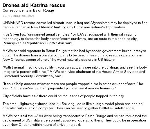
Commerce Dept. NOAA AND PARTNERS CONDUCT FIRST SUCCESSFUL UNMANNED AIRCRAFT HURRICANE OBSERVATION BY FLYING THROUGH OPHELIA
|
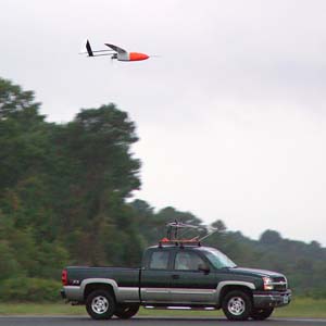
Sept. 16, 2005 - Hurricane researchers at the NOAA Atlantic Oceanographic and Meteorological Laboratory in Miami, Fla., marked a new milestone in hurricane observation as the first unmanned aircraft touched down after a 10-hour mission into Tropical Storm Ophelia, which lost its hurricane strength Thursday night. The aircraft, known as an Aerosonde, provided the first-ever detailed observations of the near-surface, high wind hurricane environment, an area often too dangerous for NOAA and U.S. Air Force Reserve manned aircraft to observe directly. (Click image for larger view of the Aerosonde unmanned aerial vehicle being released from its transport vehicle on the runway at the NASA Wallops flight Facility, in Wallops Island, Va., to fly into and take measurements of Tropical Storm Ophelia on Sept. 16, 2005. Click here for high resolution version. Photo courtesy of NASA.)
"It's been a long road to get to this point, but it was well worth the wait," said Joe Cione, NOAA hurricane researcher at AOML and the lead scientist on this project. "If we want to improve future forecasts of hurricane intensity change we will need to get continuous low-level observations near the air-sea interface on a regular basis, but manned flights near the surface of the ocean are risky. Remote unmanned aircraft such as the Aerosonde are the only way. Today we saw what hopefully will become 'routine' in the very near future."
NOAA's partners in this effort include the Aerosonde company, which designed and operates the aircraft, and NASA Goddard's Wallops Flight Facility, located on Virginia's Eastern Shore, which houses the U.S. base for Aerosonde North America and served as the departure and landing location for this historic flight. The Aerosonde hurricane project is funded by NASA and NOAA Research in order to test this promising new observational tool.
|
|
"The concept of the Aerosonde as a small, robust unmanned autonomous vehicle, or AUV, arose directly from our need for observations in dangerous areas such as the hurricane surface layer," said Greg Holland, president of Aerosonde North America and one of the Aerosonde originators. "I am particularly grateful to the hard work by Aerosonde staff and the support of NOAA and NASA that has now made this possible."
The Aerosond was launched at about 7:30 a.m. EDT on Friday and returned at about 5:30 p.m. "in pristine condition," according to Aerosonde North America.
While the successful use of NOAA's WP-3D Orion, its Gulfstream-IV aircraft and the U.S. Air Force Reserve's WC-130H aircraft have been important tools in the arsenal to understand tropical cyclones, detailed observations of the near-surface hurricane environment have been elusive because of the severe safety risks associated with low level manned flight missions. The main objective of the Aerosonde project addresses this significant observational shortcoming by using the unique long endurance and low-flying attributes of the unmanned Aerosonde observing platform, flying at altitudes as low as 500 feet. Tropical Storm Ophelia provided the perfect test case for using Aerosondes as it was a minimal hurricane within flight range of the Wallops Flight Facility.
The Aerosonde platform that flew into Ophelia was specially outfitted with sophisticated instruments used in traditional hurricane observation, including instruments such as mounted Global Position System (GPS) dropwindsondes and a satellite communications system that relayed information on temperature, pressure, humidity and wind speed every half second in real-time. The Aerosonde also carried a downward positioned infrared sensor that was used to estimate the underlying sea surface temperature. All available data were transmitted in near-real time to the NOAA National Hurricane Center and AOML, where the NOAA Hurricane Research Division is located. |
|
The environment where the atmosphere meets the sea is critically important in hurricanes as it is where the ocean's warm water energy is directly transferred to the atmosphere just above it. The hurricane/ocean interface also is important because it is where the strongest winds in a hurricane are found and is the level at which most citizens live. Observing and ultimately better understanding this region of the storm is crucial to improve forecasts of hurricane intensity and structure. Enhancing this predictive capability would not only save the U.S. economy billions of dollars, but more important, it could save many lives.
Accomplishments from this first flight include detailed documentation of an unsampled region of the hurricane while simultaneously providing the NOAA National Hurricane Center with real-time near surface wind and thermodynamic data from within Tropical Storm Ophelia. In addition, detailed comparisons between in-situ and satellite-derived observations also will be possible. It is also envisioned that this unique data could ultimately be used to help initialize and verify both operational and research-oriented numerical simulations. - noaa.gov
|
|
| Doppler Radar - a pulse of energy
|
How does NEXRAD work?
NEXRAD (Next Generation Radar) obtains weather information (precipitation and wind) based upon returned energy. The radar emits a burst of energy (green). If the energy strikes an object (rain drop, bug, bird, etc), the energy is scattered in all directions (blue). A small fraction of that scattered energy is directed back toward the radar.
This reflected signal is then received by the radar during its listening period. Computers analyze the strength of the returned pulse, time it took to travel to the object and back, and phase shift of the pulse. This process of emitting a signal, listening for any returned signal, then emitting the next signal, takes place very fast, up to around 1300 times each second.
NEXRAD spends the vast amount of time "listening" for returning signals it sent. When the time of all the pulses each hour are totaled (the time the radar is actually transmitting), the radar is "on" for about 7 seconds each hour. The remaining 59 minutes and 53 seconds are spent listening for any returned signals.
|
|
The phase of the returning signal typically changes based upon the motion of the raindrops (or bugs, dust, etc.). This Doppler effect was named after the Austrian physicist, Christian Doppler, who discovered it. You have most likely experienced the "Doppler effect" around trains.
As a train passes your location, you may have noticed the pitch in the train's whistle changing from high to low. As the train approaches, the sound waves that make up the whistle are compressed making the pitch higher than if the train was stationary. Likewise, as the train moves away from you, the sound waves are stretched, lowering the pitch of the whistle. The faster the train moves, the greater the change in the whistle's pitch as it passes your location.
The same effect takes place in the atmosphere as a pulse of energy from NEXRAD strikes an object and is reflected back toward the radar. The radar's computers measure the phase change of the reflected pulse of energy which then convert that change to a velocity of the object, either toward or from the radar. Information on the movement of objects either toward or away from the radar can be used to estimate the speed of the wind. This ability to "see" the wind is what enables the National Weather Service to detect the formation of tornados which, in turn, allows us to issue tornado warnings with more advanced notice. - crh.noaa.gov
|
|
New Radar Technology Can Increase Tornado Warning Lead Times
Navy's phased array radar being adapted for weather use
A National Weather Radar Testbed has been established at the National Oceanic and Atmospheric Administration's National Severe Storms Laboratory to provide the meteorological research community with the first surveillance phased array radar facility available on a full-time basis. Norman is already known as a national center for weather radar research and development. NSSL's research in Doppler radar led to one of the most successful and significant technology advancements since the launching of the first weather satellite. Nearly 30 years ago, NSSL was a major participant in the development of Doppler technology that became the heart of the WSR-88D radar, or NEXRAD. The deployment of a system of 120 NEXRAD radars across the United States was the cornerstone of the modernization of the National Weather Service.
Phased array radar technology may help forecasters of the future provide earlier warnings for tornadoes and other types of severe and hazardous weather. Researchers are adapting the SPY-1 radar technology, developed by Lockheed Martin to support tactical operations aboard Navy ships, to weather detection. The phased array radar project has begun a new stage in NSSL's leadership in the research and development of future generations of weather radar.
|
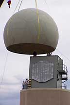
Installation of the SPY-1A antenna and radome on the NWRT
|
|
Research Partnerships
A unique federal, private, state and academic partnership is developing the phased array radar technology. Participants include NOAA's National Severe Storms Laboratory and National Weather Service Radar Operations Center, Lockheed Martin, U.S. Navy, University of Oklahoma's School of Meteorology and School of Electrical and Computer Engineering, Oklahoma State Regents for Higher Education, the Federal Aviation Administration, and Basic Commerce and Industries. The project - from research and development to technology transfer and deployment throughout the U.S. - is expected to take 10 to 15 years at an initial cost of approximately $25 million for the facility in Norman.
|
|
Promising New Radar Technology
Early tests of the phased array radar system show that the technology has the potential to vastly improve upon the capabilities of the national NEXRAD radar network for all weather radar applications. Using multiple beams and frequencies, phased array radar reduces the scan time of weather from five or six minutes for NEXRAD radar to less than one minute, producing fast updates of weather data.
The National Weather Radar Testbed allows NSSL and other meteorologists to determine if phased array radar will become the next significant technology advancement to improve our nation's weather services.
|
|
|
The rapid scanning ability of phased array radar gives it the potential to be a multi-use, adaptively scanning radar.
Improved Warning Lead Time
In addition to faster updates, the new system can scan the atmosphere with more detail at lower elevations than current radar allows. It can also re-scan areas of severe weather very quickly, potentially increasing forecasters' warning lead times as storms rapidly transition to severe modes.
PAYOFF: This technology has the potential to increase the average lead time for tornado warnings well beyond the current average of 11 minutes. Other technology being developed at NSSL will extend lead times even farther.
|
|
|
Improved Understanding and Forecasts
The new technology will gather storm information not currently available, such as rapid changes in wind fields, to provide more thorough understanding of storm evolution. Researchers and forecasters can then improve conceptual storm models and use that knowledge to evaluate and improve stormscale computer models. The data will also be used to initialize computer models and improve forecasts.
PAYOFF: Phased array technology will increase fundamental understanding of storm evolution, in turn leading to improved computer models, more accurate forecasts and earlier warnings.
Reflectivity and velocity displays of the first tornadic storm captured with the NWRT
norman.noaa.gov
|
|
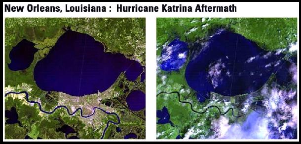
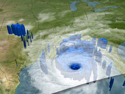
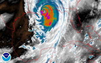
Real-time radar data and high-tech communications were the keystones to success this past weekend as the Rainband and Intensity Change Experiment (RAINEX) project began its research with Hurricane Katrina. The project is funded by the National Science Foundation (NSF).
|
Rainband and Intensity Change Experiment
Scientists from the RAINEX project flew into the edge of Hurricane Katrina on Aug. 27 and Aug. 28 to study its rainbands and the formation of its eyewall, taking simultaneous measurements from two aircraft as Katrina grew into Category 5 and bore down on the Gulf Coast. Credit: NOAA water vapor satellite image
RAINEX became the first hurricane research project to fly planes nearly simultaneously inside and outside a hurricane's principal rainband, gathering information that will help scientists to better understand changes in a hurricane's intensity.
RAINEX is studying the interaction between hurricane winds and rain, using data recorded from hurricane research flights, according to Steve Nelson, program director in NSF's atmospheric sciences division, which funded RAINEX. For six weeks of this year's active hurricane season, two research aircraft will fly simultaneously into hurricanes before the storms make landfall.
Flying in the hurricane's outer bands and eyewall on most flights, the aircraft are using sophisticated Doppler radar and Global Positioning System dropsondes to record wind speed and direction, temperature, humidity, atmospheric pressure, and other critical data.
|
|
"While the forecasting of hurricane tracks has come a long way, that kind of information results from a variety of variables external to the hurricane," says Robert Houze, an atmospheric scientist at the University of Washington and a RAINEX principal investigator. "Intensity is driven in part by internal dynamics between the rainbands and the eyewall - something that is very hard to get to - so this is landmark information that will help us to understand this phenomenon better."
Shuyi Chen, a meteorologist and physical oceanographer at the University of Miami Rosenstiel School of Marine and Atmospheric Sciences (RSMAS), also a RAINEX principal investigator, developed a fine-resolution, coupled atmosphere-wave-ocean computer model to study hurricane intensity changes. While most models estimate atmospheric activity down to tens of kilometers, her model goes further - down to a kilometer or two, filling in information gaps and providing realistic rainband and eyewall structure simulation. Researchers are able to use the model in combination with airborne Doppler radar measurements to better understand hurricane intensity changes.
"The airborne radar data come into our operations center in real-time," said Chen. "We process it, and then share it with the research planes within a few minutes. This helps the planes navigate and position themselves appropriately, and it helps us guide planes to exactly the area of the hurricane where we want to take measurements. It's the first time we have ever tried this new way of communicating from the ground to planes flying in a hurricane."
RAINEX also involves scientists from the National Center for Atmospheric Research (NCAR) in Boulder, Colo., the National Oceanic and Atmospheric Administration (NOAA), and the U.S. Navy.
physorg.com
|
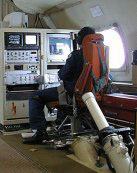
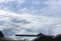
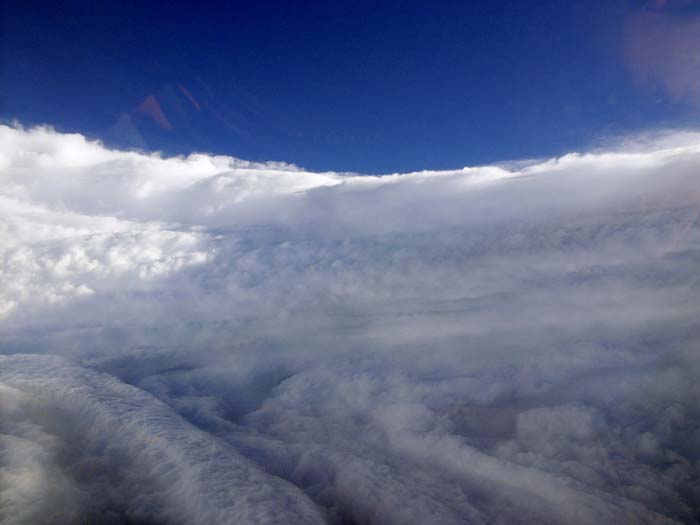
INSIDE the eye of the storm
|
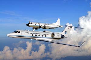
NOAA hurricane hunter WP-3D Orion and Gulfstream IV aircraft in flight
|
NOAA HURRICANE HUNTER PILOT CAPTURES KATRINA AT HER MEANEST
Sept. 1, 2005 - NOAA hurricane hunter WP-3D Orion and Gulfstream IV aircraft conducted ten long flights into and around the eye of Hurricane Katrina. Lt. Mike Silah, a P-3 pilot, got to see Hurricane Katrina up close and personal, especially when she was an extremely dangerous Category Five storm in the Gulf of Mexico. The day before the powerful and destructive storm made landfall on the USA Gulf Coast, Silah snapped a series of images capturing the eyewall of Katrina. - noaanews
|
Katrina's eyewall as seen from the NOAA P-3 hurricane hunter aircraft on Aug. 28, 2005, a day before the powerful storm came crashing into the USA Gulf Coast.
|
|
RAINEX will study this interaction using data recorded from hurricane research flights. Beginning Aug. 15 through the remainder of this year's Atlantic hurricane season, two NOAA P3 aircraft, along with a U.S. Navy P3 aircraft will fly simultaneously into hurricanes well before they threaten landfall. Flying in the hurricane's outer bands and punching into the eyewall on most flights, the aircraft will use sophisticated Doppler radar and GPS dropsondes to record wind speed and direction, temperature, humidity, atmospheric pressure, and other critical data.
The University of Washington and NCAR will provide expertise in airborne Doppler radar analysis. Rosenstiel School will construct a state-of-the-art hurricane model using the data collected from the research flights.
The University of Washington and NCAR will provide expertise in airborne Doppler radar analysis. Rosenstiel School will construct a state-of-the-art hurricane model using the data collected from the research flights.
"National Science Foundation funding allows the Navy aircraft to be added to the research. It will play a key role by observing the outer part of the storm while the other two aircraft observe the inner part," said Dr. Robert A. Houze Jr., a professor in atmospheric sciences at the University of Washington and a principal investigator. "Ideally, we'll obtain a physical explanation of a hurricane's intensity change in terms of the relationship between the inner and outer parts of the storm. These storms can jump up in intensity or drop a full category in a day, and the intensity changes are a big challenge."
Much of what scientists currently know about the interaction between the outer rainbands and the eyewall of a hurricane comes from the state-of-the-art numerical models developed for hurricane research and prediction, which can provide very detailed information but may not be completely accurate. But what researchers need is solid data to validate these models.
One of the breakthrough aspects of RAINEX is the use of the three Doppler radar-equipped aircraft. Although eyewall flights are a routine part of hurricane research, this is the first field study to include simultaneous flights in and near rainbands.
- uwnews.org
High strangeness...yet another photo psyop set to distract & confuse
|
|
what all of the above stories seem to be implying, is that these planes fly into storms collect measurements, land...then all the data is analysed and is used in restructuring computer models for simulations
Hang on! what year is this???
where is thre REAL TIME sending and analysing?
|
"The airborne radar data come into our operations center in real-time," said Chen. "We process it, and then share it with the research planes within a few minutes. This helps the planes navigate and position themselves appropriately, and it helps us guide planes to exactly the area of the hurricane where we want to take measurements. It's the first time we have ever tried this new way of communicating from the ground to planes flying in a hurricane."
RAINEX also involves scientists from the National Center for Atmospheric Research (NCAR) in Boulder, Colo., the National Oceanic and Atmospheric Administration (NOAA), and the U.S. Navy. -
physorg.com
|
OK....where was the data? where were the WARNINGS?
|
|
|
Note the graphic [left]
why not fly researcher aircraft into the storm when it hit land at Florida?
This was the optimum potential for change...and as we now know the storm entered the Gulf and became a higher category...
was this due to warmer waters in the gulf? why were these potential threats not reported as a possibilty???
|
| Doppler Radar - a pulse of energy
|
NEXRAD spends the vast amount of time "listening" for returning signals it sent. When the time of all the pulses each hour are totaled (the time the radar is actually transmitting), the radar is "on" for about 7 seconds each hour. The remaining 59 minutes and 53 seconds are spent listening for any returned signals.
The phase of the returning signal typically changes based upon the motion of the raindrops (or bugs, dust, etc.).
Isn't another very popular scientific maxim being avoided here?
Cause & Effect
|
|